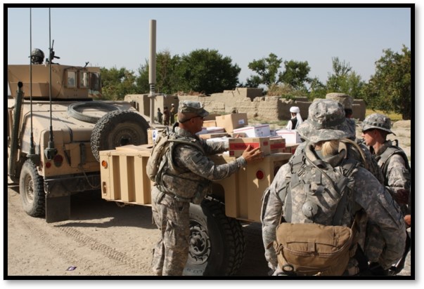
CIS Project work has focused on supporting the U.S. military’s efforts, particularly the civil affairs community, to improve the collection and use of civil information. Civil information is that data that helps both military and civilian decision makers understand and support the needs of the civilian population during times of disaster and conflict. Because food is one of the most critical human needs, the CIS Project has most focused its part of this effort on identifying the data and conducting analysis that helps commanders and civilian decision makers understand food systems and food needs of civilian populations.
The CIS Project’s initial work in food systems was developed through support from the Defense Threat Reduction Agency (DTRA), which was looking to develop models to identify and assess the resiliency of food systems during times of natural disaster or conflict, what the military terms Humanitarian Assistance/Disaster Response (HADR) efforts. The purpose of this research was to assist commanders in making decisions on what needed to be protected or restored in post-disaster and post-conflict environments to maintain food security. The military has long understood that food insecurity can be a trigger to social instability and conflict.
The CIS Project has taken the work from the DTRA research effort and has now applied it to supporting the Army’s Civil Affairs command in improving the collection and analysis of civil information, which is information on those entities needed to support a civilian population. This includes such things as water and sewer systems, energy, transportation, medical, educational systems and more. Included in this work is that of collecting better data on food systems and showing in what way local food systems are connected to and dependent upon some of these other civilian systems.
While much of the concern regarding food insecurity is focused on less-developed and less-stable regions of the world, the reality is that food systems in developed nations, including the United States, face continuous threats that, when manifest, can trigger localized, regional or national food insecurity. At any given time, any local region has only a three-day supply of food when the food system is disrupted. Like military commanders deployed abroad, decision makers in the U.S., whether in government, the military or private sector, struggle to gain an understanding of food systems and how seemingly unrelated factors or events within the overall food system can trigger food insecurity. Such an understanding can provide not only government decision makers, but also members of the food production, processing and distribution industries, with valuable information that help them make food systems more resilient.
The CIS Project views its domestic version of its work as a homeland security planning and response tool that can assist state National Guard, state and local emergency managers, and those who are part of local food systems prepare and respond to natural disasters, man-made disasters and terrorism incidents.
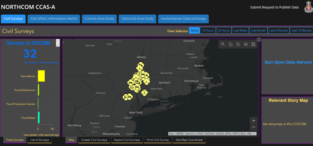
Currently, the CIS Project is developing a test case of the domestic version of its food system project in the New York’s Hudson Valley. This Hudson Valley test case is using the data collection surveys, analysis tools and mapping system developed for the military and applying that to identifying and mapping a local food system in the Hudson Valley. Through the test case, the CIS Project will introduce domestic emergency managers to the value of collecting the data that can identify the critical network that moves food from production points to distribution points in support of civilian populations.
The long-term aim of the CIS Project is to engage federal, state and local emergency managers, homeland security officials, the food system industry and organizations with an interest in food security to participate in data collection efforts across the country. This will ultimately result in a national database from which one can access data and map any local food system in which data has been collected and uploaded to the system. The Hudson Valley test case will be the first step in this long-term objective.
Food System Data Collection Project:
The CIS Project’s food system mapping project is leveraging civil information collection and mapping tools developed through Department of Defense-supported projects. The DoD effort is focused on improving the collection of civil information and the use of that information to assist military commanders in identifying and assessing critical infrastructure that must be protected to support the civilian population.
The DoD effort resulted in the creation of a commercial version that allows for its use by not only military units (including state National Guards) but also non-military entities, such as civilian U.S. government agencies (federal, state and local), civilian non-governmental organizations and private sector entities, as well as the general public. This commercial version makes it possible for both military and civilian entities to share the information they collect on critical civilian infrastructure. This would make it so that all can use this data to identify important infrastructure that is vulnerable in case of disaster and that must be protected or quickly restored in times of crisis.
The CIS Project has undertaken the task of testing the use of the DoD-supported effort to support community-level disaster planning and response. Because food is a critical human need, the CIS Project has focused this testing effort on data collection and mapping of local food systems. The initial test case is in the upper Hudson Valley region of New York.
The Food System Data Collection and Mapping project uses those data collection surveys developed by DoD that apply to food systems, such as the farm, food store, food warehouse, processing and storage, water systems, etc. surveys. The data from these surveys is automatically uploaded to a database that then maps these food system entities. Through this data collection and mapping system, the connections among entities within a local food system become visible as well as information on the capacity of those entities. In addition, if overlaid with other data mapping efforts, it becomes possible to identify which entities of a local food system infrastructure are located within risk zones, such as the potential path of a natural disaster.
The Hudson Valley test case is a small step forward. It is the ultimate objective of this CIS Project effort to make it possible for communities not only across the U.S., but across the world, to use the system to collect data and map their own local food systems. This would give not only local decision makers but also the population within communities the ability to use this information to assess their own food system strengths and vulnerabilities.